Iceland Erupts; Volcanic Activity on the Reykjanes Peninsula
While the rest of the world is missing getting to visit and explore Iceland’s epic landscapes, nature has been building up to change that landscape once more!
Location Background
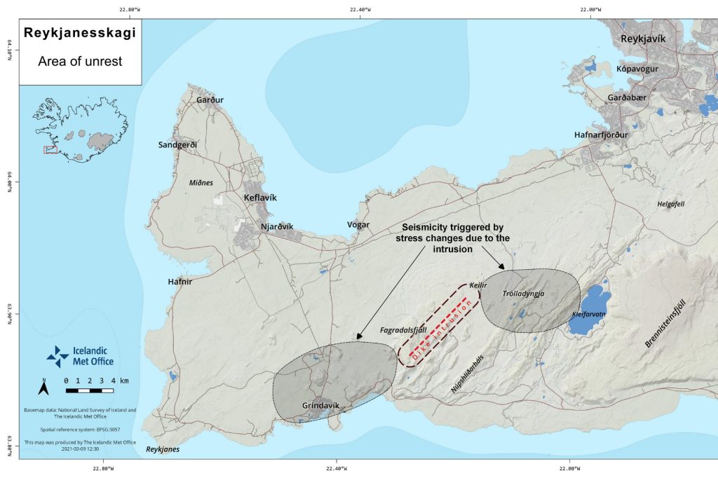
The Reykjanes peninsula is an active volcanic system located in southwest Iceland. As with much of Iceland, there is only a sparse local population aside from the town of Reykjanesbaer, however the main international airport at Keflavik and the infamous Blue Lagoon are found here and it is just a short drive to the capital Reykjavik. The area boasts beautiful coastlines, dormant and active volcanoes, vast ancient lava fields, bubbling and steaming hot springs and geothermal areas, and traditional Icelandic stories.
Map Credit: Icelandic Met Office – https://en.vedur.is/about-imo/news/earthquake-swarm-in-reykjanes-peninsula

Recently, seismic activity has begun to increase along the ridge fault zones. The volcanic belt here is a continuation of the Mid-Atlantic Ridge, creating various areas of displacement and fissures alongside craters, ravines and faults. Hengill is the most famous of the volcanoes here, and received media attention in 2020 when activity increased. The peninsula is composed mostly of basaltic lavas from historic eruptions (please see our resource ‘Lavas of Iceland’ for a geology map). Iceland is famous for its geology and volcanic activity, having been created by rifting, as well as hotspot activity with upwelling of magma from the mantle that is then released as the plates separate. The peninsula itself originated some 6-7 million years ago during a ‘rift jump’ when the active rift had drifted away from the hotspot and then activity moved eastwards towards the mantle plume under Vatnajökull glacier. Volcanoes along the peninsular are both aerial and in places partially submarine, comprising an array of shield volcanoes, fissures and crater rows.
Timeline of activity
Since 24th February earthquake swarms of moderate intensity (including over 5M) have increased in the area, and at shallow depth. By 4th March the Icelandic Met Office, which gives warnings and information regarding hazards, placed a warning of larger earthquakes across the whole area and advised the public to avoid steep terrain and beware of rockfalls and unstable ground. Geoscientists and geologists were deployed to take gas measurements and assess indications of potential volcanic activity. The Civil Protection Department then declared an alert phase for the peninsula and you can find official guidance on earthquake preparedness here.
From 5th March officials advised against all travel into the immediate vicinity (other than for scientists and emergency services), due to the risk of avalanches and rock falls, as well as unstable ground and potential for gas venting. On 11th March an ash-radar detection station was installed on a lava field at Strandarheiði to be used for monitoring atmospheric particles in the event of a future eruption, with the intention of using the information to model the path of ash flows and predict any spread that could lead to the necessity to cancel air traffic across Europe as in 2010.
Powerful swarms such as these are known to occur in the area approximately every 25 years, however the most recent earthquake swarm was powerful enough to be felt across the island and it was predicted that these were due to magma movements towards the crust and that an effusive lava-producing eruption may occur close to Keilir. Analysis of data from InSAR (satellite-based radar) and modelling throughout the week of 14th March showed displacement and ground deformations were taking place, indicating a likelihood of magma intrusions with magma estimated to have reached one kilometre below the surface. The earthquake swarm registered over 34’000 events in a fortnight, more than was measured throughout the whole of 2020! Any eruption here would be the first for 800 years, and it was therefore considered ‘due’.
Geophysical surveys were conducted along the area between Fagradalsfjall and Keilir, with the results used for computer modelling and to suggest how the magma chamber is expanding below ground. Geophysicist Freysteinn Sigmundsson on 9th March stated that the growing magma reservoir was in the form of a volcanic dike approximately 1 metre wide by 7 kilometres long and reaching to a maximum depth of 5 kilometres. Magmatic influx was enabling magma to flow from deeper stores towards the shallower magma chamber, and based on the rate of ground deformation it was estimated that the rate of magmatic influx was approximately 15-20 cubic metres per second. It was then suggested that material below Keilir was likely to be cooling and solidifying as the magma chamber is deeper here, whereas near Fagradalsfjall the chamber is only a kilometre below the surface and has more seismic activity. Therefore, predictions were changed to suggest any future eruption was most likely to be focused near here. Due to the nature of the geology, it was predicted that any eruption would be similar in style to the 2010 Fimmvorduhals (Eyjafjallajökull) fissure eruption and therefore producing lava fountains and large lava flows, but not likely to have an explosive stage, as there is no interaction with ice or water to create phreatomagmatic behaviour. This led scientists and alert agencies to generate detailed information for local populations that stated the risk to human life was very low.

Iceland Erupts!
In the middle of the evening on Friday 19th March, the eruption finally began! Interestingly, according to seismographs, earthquake activity actually lessened in the hours just preceding the eruption. The dyke intrusion finally broke the surface, and subsequent basalt lava flows were released.
The volcano itself is in a closed valley called Geldingardalur (which literally means Valley of Castration!), at the foot of a large volcanic ridge called Fagradalsfjall, which translates to: ‘Fagra’ (beautiful), ‘dal’ (valley), fjall (mountain). The area had been dormant for nearly 800 years and there has been no eruption at the volcano itself for 14000 years! However, it is likely that activity could now be ‘jump started’ with potential volcanism in the region for the next thirty years (as occurred during the 1210-1240 eruption, with sporadic episodes). It is unknown how long the current eruption will last, until more remote sensing is possible to detect whether the magma reservoir has been exhausted or is being replenished.
The eruption is effusive style, creating fire fountains that have, at times, reached 100m high, and with two main pahoehoe lava streams. There are live web cams (links below) that show the eruption is not currently creating a large lava flow, although activity can of course change. There is no eruption column cloud, and the lack of interaction with water means there is minimal ash production and explosivity. However, there are toxic gases, particularly SO2. Computer modelling and meteorological surveys have allowed authorities to warn residents downwind to keep windows and doors closed, and to avoid going outside. Currently the active fissure has reached 500m in length, with lava flows covering 1km2.
Management of the area:
Iceland is extremely well organised with regards to volcanic activity, with specialist organisations and agencies involved in providing real time information to the public. Ahead of the eruption, airports were closed to reduce the risk of potential volcanic aerosols causing damage to aircraft, but they have currently reopened and you can witness the lava flows as your plane lands!
The region is largely uninhabited, reducing the need for emergency services to be involved currently, although they are on alert. The public was warned to stay clear, but once the eruption began there was an influx of locals driving to witness the eruption from a safe distance! Volcano tourism is still alive and well! Volcanic gas emissions are being continually assessed in order to keep populations safe downwind. Aircraft have been deployed to monitor the situation, and computer modelling using remote sensing is key. The location has been described as ‘ideal’ since the lava flows are essentially contained within the valley sides as if filling up a bathtub! In fact, professor Magnús Tumi Guðmundsson has stated that “people can sleep soundly now” as the location is so ideal and the eruption poses no immediate danger, and finally the Icelanders might get a break from the recent persistent earthquakes! However, due to the low ground in the valley it is possible that poisonous gases could collect here and so people are advised to stay home and watch it on the tv.

You can access more information via these links:
https://www.visindavefur.is/ (can be translated into English via web browser)
BBC interview with Icelandic geologists ahead of the eruption
Expert interview before the eruption
Introducing the ash radar additional monitoring
http://bit.ly/3lAPFK9 and http://bit.ly/3c92XuF– Civic advice for preparation and preparedness
Iceland Geology Seismic & Volcanic Activity facebook group
Geography Teacher Zone Facebook group with regular updates
Forecast of gas and aerosol dispersal
Overview of the geology involved
There are various live stream web cams for the area:
Currently the best for a close up view of the lava flow
http://bit.ly/3kLHdHy , http://bit.ly/3qbuX4x , https://vimeo.com/519427614
Other media links:
Drone footage from start of the eruption
Geology with Helga Instagram account where you can ask questions!
http://bit.ly/3eTBFdo and https://bit.ly/3cQp47Z – videos of 5.4 earthquake on 14th March at Nátthagi
Education webinar ‘Iceland Awakes’ which was shared ahead of the eruption but gives useful context
Seismograph showing activity immediately before the eruption


